Azimuthal Gamma Ray Sensor Sub: Advanced Formation Evaluation for Precision Geosteering
The Formation Resolution Challenge
Conventional gamma ray tools face detection limitations:
-Signal attenuation through thick non-magnetic walls and annular gaps
-Poor bed boundary resolution in complex layered formations
-Delayed response to rapid lithology changes
-Insufficient data density for precise geosteering decisions
Our azimuthal gamma ray sensor sub delivers:
✅ Enhanced formation resolution through optimized detector placement
✅ Real-time geological insight for immediate steering corrections
✅ Superior bed boundary detection within ±0.5ft accuracy
✅ Adaptive configuration for different hole sizes
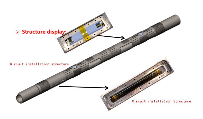
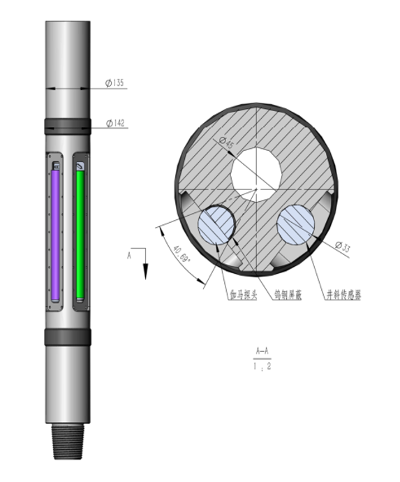
Dual-Configuration Technology
Wall-Contact Azimuthal Gamma (8″+ Hole Size)
| Feature | Advantage | Technical Benefit |
| Direct wall contact | Minimal signal attenuation | Maximum formation signal strength |
| Reduced standoff | Closer proximity to formation | Higher resolution measurement |
| Thin non-magnetic housing | Less gamma ray absorption | Improved counting statistics |
| Multiple sector measurements | 4-8 azimuthal sectors | Detailed radial formation profile |
Probe-Type Azimuthal Gamma (6.75″- Hole Size)
| Feature | Advantage | Technical Benefit |
| Slim design | Fits restricted diameters | Maintains directional capability |
| Centralized measurement | Consistent wellbore coverage | Reliable quadrant detection |
| Optimized sensor placement | Balanced signal quality | Accurate formation evaluation |
Technical Specifications
| Parameter | Wall-Contact Type | Probe-Type |
| Hole Size Range | 8″ and larger | 6.75″ and smaller |
| Azimuthal Sectors | 4 or 8 sectors | 4 sectors |
| Measurement Range | 0-500 API | 0-400 API |
| Sample Rate | 2-8 samples/ft | 2-4 samples/ft |
| Temperature Rating | 175°C | 150°C |
| Pressure Rating | 25,000 psi | 20,000 psi |
| Data Transmission | Wired pipe or mud pulse | Wired pipe or mud pulse |
Operational Advantages
-Enhanced Geological Insight
Detect thin beds as narrow as 0.3ft thickness
Identify formation dip from azimuthal response patterns
Monitor lithology changes in real-time for geosteering decisions
-Improved Drilling Efficiency
Make steering decisions 30-50% faster with higher confidence data
Reduce unnecessary steering corrections by accurately identifying bed boundaries
Optimize well placement within target zones with precision
-Risk Mitigation
Early warning of approaching formation boundaries
Prevent unintentional exits from target zones
Minimize geological uncertainty in complex reservoirs
Field Applications
Geosteering Operations: Maintain wellbore in sweet spot of unconventional reservoirs
Thin Bed Reservoirs: Accurately navigate complex layered formations
Boundary Detection: Identify roof and floor contacts in coal seam or shale drilling
Formation Evaluation: Provide high-resolution gamma data for reservoir characterization