


Resistivity & Azimuth Gamma Sub: Multi-physics 2MHz/500kHz 8-curve symmetric compensation reservoir navigation vs. basic logging tools
Navigating complex, heterogeneous reservoirs with thin pay zones, structural dips, and fluid-contact transitions requires far more than simple, uncompensated single-curve logs. Basic logging tools often suffer from borehole rugosity distortion, shoulder-bed effects, and lack of directional look-ahead or look-around capability, causing operators to miss sweet spots or drill prematurely into water or gas zones. When evaluating Resistivity & Azimuth Gamma Sub: Multi-physics 2MHz/500kHz 8-curve symmetric compensation reservoir navigation vs. basic logging tools, the operational advantage of multi-frequency electromagnetic propagation paired with directional gamma imaging is decisive. The advanced Resistivity & Azimuth Gamma Sub combines dual-frequency (2 MHz and 500 kHz) electromagnetic wave propagation with an 8-curve symmetrically compensated measurement architecture and azimuthal gamma ray sectoring, delivering real-time multi-physics reservoir navigation in challenging horizontal and extended-reach wellbores.
1. Engineering Architecture of Multi-Physics Reservoir Navigation
Unlike basic logging tools that rely on single-frequency or non-compensated sensors prone to environmental drift, this integrated LWD sub unites electromagnetic and nuclear measurements in a ruggedized collar.
- Dual-Frequency Electromagnetic Propagation (2 MHz / 500 kHz): Operates at 2 MHz for shallow, high-vertical-resolution bed-boundary detection and 500 kHz for deeper radial investigation into the formation, capturing both phase-shift and attenuation responses across multiple transmitter-receiver spacings.
- 8-Curve Symmetric Compensation Architecture: Uses symmetrically arranged transceiver coils to cancel out borehole enlargement, mud-resistivity shifts, and tool-tilt artifacts, generating a balanced 8-curve dataset (phase and attenuation across multiple spacings and frequencies) for accurate true resistivity ($R_t$) and invasion profiling.
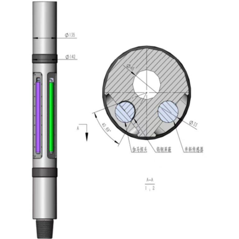
- Integrated Azimuthal Gamma Ray Sectoring: Pairs real-time directional gamma ray mapping with resistivity logs to distinguish lithology changes (such as shale vs. sand) from fluid-saturation shifts (such as hydrocarbon vs. brine), preventing false steering calls.
2. المزايا التشغيلية الرئيسية
- Pinpoint Pay-Zone Geosteering: Combines 2 MHz high-resolution boundary sensitivity, 500 kHz deep investigation, and azimuthal gamma imaging to keep the bit locked inside narrow or dipping reservoirs.
- Superior Environmental Compensation: Symmetric coil compensation minimizes shoulder-bed and borehole-washout distortions, providing cleaner real-time logs in complex formations and varying mud systems.
- Lithology-vs.-Fluid Clarity: Multi-physics correlation helps teams separate true stratigraphic changes from fluid-contact interfaces, reducing costly sidetracks and maximizing reservoir drain efficiency.
3. متانة قاع البئر والمواد المستخدمة
Built into a high-tensile non-magnetic alloy steel collar with shock-isolated electronics, recessed antenna guards, and thermal compensation circuitry, the sub withstands severe rotary shock, high vibration, and harsh HPHT downhole conditions.
4. الخاتمة
High-precision reservoir navigation demands multi-physics clarity rather than basic, single-dimension logging snapshots. By deploying the Resistivity & Azimuth Gamma Sub with 2 MHz/500 kHz dual-frequency propagation, 8-curve symmetric compensation, and azimuthal gamma tracking, operators achieve sharper geosteering decisions, fewer geosteering surprises, and higher well productivity.