Drilling Resistivity Measurement Device: Real-Time Formation Insight for Optimal Well Placement
The Real-Time Reservoir Evaluation Challenge
Drilling without accurate, real-time resistivity data leads to:
⚠️ Inability to distinguish pay zones from non-productive formations while drilling
⚠️ Increased risk of drilling out of zone, missing productive intervals
⚠️ Delayed reservoir characterization, requiring costly wireline runs
⚠️ Suboptimal completion decisions due to lack of early formation evaluation
Our Drilling Resistivity Measurement Device Delivers:
✅ Simultaneous multiple depths of investigation (shallow, medium, deep)
✅ Real-time data for immediate geosteering decisions and formation evaluation
✅ Robust performance in diverse mud types (water-based, oil-based, synthetic)
✅ High-resolution logs comparable to wireline quality
Design Features & Working Principle
Multi-Frequency Electromagnetic Wave Technology
| Feature | Specification | Functional Benefit |
|---|---|---|
| Transmitter Array | Multi-frequency, multi-spacing transmitters | Provides multiple depths of investigation for accurate Rt (true resistivity) determination |
| Receiver Array | High-sensitivity, phase-sensitive receivers | Measures both signal amplitude attenuation and phase shift for robust data |
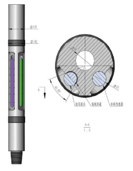
| Azimuthal Imaging | Segmented electrodes or oriented antennas | Creates high-resolution borehole image for structural interpretation |
| Inversion Software | Real-time 1D/2D inversion algorithms | Converts raw measurements into accurate formation resistivity and images |
Technical Specifications
| Parameter | Specification |
|---|---|
| Measurement Types | Azimuthal Resistivity, Attenuation, Phase Shift, Gamma Ray (optional) |
| Depths of Investigation | Shallow (6in), Medium (20in), Deep (60in+) |
| Operating Frequency | 2 kHz, 100 kHz, 400 kHz, 2 MHz (range) |
| Operating Pressure | Up to 25,000 psi |
| Temperature Rating | -20°C to 175°C (HPHT version: 200°C) |
| Tool Diameter | 4.75 in, 6.75 in, 8.25 in (standard) |
| Data Transmission | Real-time via mud pulse or wired drill pipe |
| Vertical Resolution | As fine as 2 inches |
Operational Advantages
Unparalleled Formation Evaluation While Drilling
- Identifies fluid contacts (oil-water, gas-water) in real time
- Accurately determines formation resistivity (Rt) for saturation calculation
- Detects thin beds and anisotropic formations
Precision Geosteering & Well Placement
- Provides early warning of approaching bed boundaries
- Enables steering within optimal productive zones
- Maximizes reservoir contact in horizontal wells
Operational Efficiency & Risk Reduction
- Eliminates or reduces need for post-drill wireline logging
- Enables informed decisions on casing points and coring intervals
- Reduces geological uncertainty and drilling risk
Field Applications & Performance Data
Application Scenarios
- Horizontal Geosteering: Maintaining wellbore in thin hydrocarbon-bearing zones.
- Exploration Wells: Early reservoir characterization and fluid identification.
- Mature Field Development: Identifying bypassed pay and optimizing infill well placement.
- Complex Clastic/Carbonate Reservoirs: Evaluating layered and heterogeneous formations.
Performance Metrics
✅ Accuracy: Resistivity measurement within ±5% of wireline benchmark
✅ Detection Distance: Capable of detecting bed boundaries up to 15-20 ft away from wellbore
✅ Data Delivery: Real-time data latency of < 5 minutes from downhole measurement to surface display
✅ Reliability: >95% tool uptime on multi-well campaigns